Thursday, June 10, 2010

Lawrence Park

The Heritage of Lawrence Park

“Lawrence Park” was named after John Lawrence and his family, who were one of the original landowners in the North Toronto region. John Lawrence and his wife, Sarah, were one of the few families living there in 1865. They owned Lot 5, which was a 190 acre property.

Aerial view of Lawrence Park in the 1930's. Photo credits: Toronto Archives

With its prime location along Yonge Street and the proximity to the expanding and prosperous Toronto, speculators became interested in buying the farmlands. Just a bit south, on Eglinton, farms where already being subdivided for urban development. Lawrence Park met the same faith in 1907 when the Dovercourt Land Building and Saving Company began the assembly of what will become the neighbourhood we know today. Under the supervision of Wilfred Servington Dinnick, the company acquired most farm lots and started to develop a suburb for the “well to do”. Dinnick’s vision was to create a “garden suburb”, similar to what was being done in England at the time.

A wood bridge crossing the ravine in 1920. Photo credits: Toronto Archives

Buyers would have to purchase a lot and have their building plans approved by a committee that was making sure all houses where following Dinnick’s vision. The company even built six homes, designed by the firm Chadwick and Beckett, to show the style that would serve as a model. But these residences where not model homes: they were to be sold or rented as soon as completed to create a wave of good people moving in the area.

The nascent district had some challenges in its early days. Because of two wars, a recession and a depression, the building of houses was interrupted. It’s only in the 1950s that Lawrence Park was completely built up.

The construction of the Fire Hall took 2 years, from 1930 to 1932. Photo credits: Toronto Archives

Navigating the area

The limits of Lawrence Park could vary depending on the map you look at. Some call portions of Bedford Park “Lawrence Park North”, while a good chunk of Lytton Park is added to the actual Lawrence Park to create “Lawrence Park South”. No matter the sources, the original neighbourhood is bound by Yonge Street to the west, Bayview Avenue to the east, Blythwood Ravine on the south and Lawrence Avenue on the north.

The area grew around Mount Pleasant Road, and is composed of tortuous streets and deep but narrow lots. Up until the 1970’s, a streetcar was running in the neighbourhood, but that changed when the Lawrence subway station opened.

Home and front garden of M. Irwin in the 1930's. Photo credits: Toronto archives

If you are a resident and you do not own a car, there are bus routes within walking distance on Yonge Street, Mount Pleasant Road, Lawrence Avenue and Bayview Avenue. For the motorists, it’s good to know that the 401 Highway is connected to both Yonge and Bayview.

Attractions

On top of being a very exclusive residential area with numerous hills, mature trees and sidewalk-free roads, Lawrence Park is a very different place to live. In the urban planning process, it was decided to keep all retail and public services on the periphery of the district. The positive result behind this thinking is an almost traffic free garden suburb. To fully experience this “quietness”, discovering the Alexander Muir Park on a romantic scenic walk would be a good starting point.

Architecture

Dinnick’s vision is still palpable nowadays, even though there is a greater variety of architectural styles. On the same street, you can see an English cottage next to a Tudor Revival. The majority of the residences where build before the 1940’s, which explain the historic feeling you get when you walk the streets.

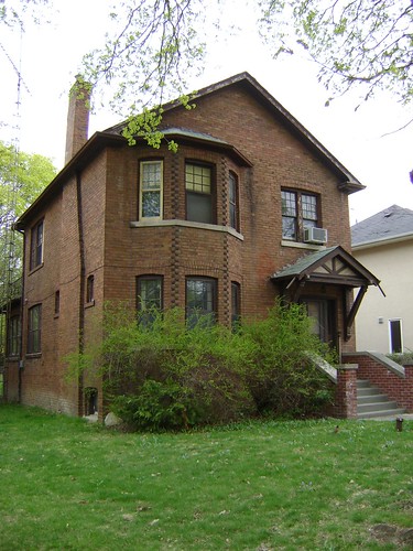
This house at 57 Glengowan is still standing intact nowadays. Photo credits: Toronto archives

What happened after the 1950s is subject to the different points of view. Some would say the newer houses are a disgrace to the area, while others would think that they are magnificent homes. Experts and real estate agents call these constructions “Monster houses”. They are big, borrow from many architectural movements, and most have a garage incorporated in their façade.

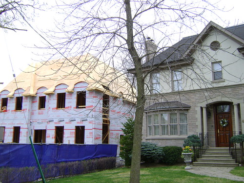
Some homeowners prefer to rebuilt new residences in place of the original houses they purchased. Photo credits: Eric Pellerin

This house will either be restored or destroyed by the next owners. Photo credits: Eric Pellerin

However, it’s not all new homeowners who decide to destroy older houses to put a monster in its place. In fact, there are a great deal of renovators out there who work with what they have and are more sensitive to preserve the old world charm of the early 20th century residences.

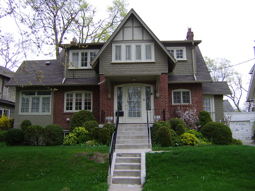
Many well known Torontonians lived in Lawrence Park. This house was first occupied in 1923 by a Thomas F. Young, of the Sterling Bond Corporation. The new owners preserved many of the original features of the house. Photo credits: Eric Pellerin

Wednesday, April 28, 2010

Deer Park ( Yonge & St.Clair )

The Heritage of Deer Park

In 1837, around the time that Toronto was founded, a woman bought 40 acres of land northwest of Yonge and Third Concession Road (now known as St.Clair). Agnes Heath, the widow of Colonel Charles Heath, called her estate Deer Park, an English translation for the native name of the area, “Mushquoteh”. The deer were living wild in the area back then, and you could see them wondering around the Hotels of the area, looking to be fed by the guests.
Agnes’ son, a lawyer named Charles Wallace Heath, bought the family farm in 1846. He had the land subdivided into 33 lots, which were all sold by 1850. The same year he became one of the original founders of the Toronto Boat Club, which changed name in 1854 to The Royal Canadian Yacht Club.

When Deer Park was annexed to the city of Toronto in 1908, the Yonge and St Clair intersection looked like this. Photo credits: City of Toronto Archives

The neighbourhood was annexed by the city of Toronto in 1908. The area became more urban and in a couple of years the farmland and villas were only a distant memory. By the 1930s, many upper-middle class families established themselves in the area. Deer park is still today one of Toronto’s finest residential districts.

Country life on St. Clair Avenue in 1911. Photo credits: City of Toronto Archives

To get in and around

The limits of Deer Park are roughly defined by the Rosedale Ravine to the east – Farnham Avenue to the south – the Belt Line trail to the north – Avenue Road and Oriole Parkway to the west. Most Torontonians know this neighbourhood for its main intersection, Yonge and St Clair, which is the commercial core of the area.

17 years before the opening of the subway, the area was still very quiet, with a very middle class twist. This photo of Avoca Avenue in 1937 shows how the area evolved (these houses are now condo towers). Photo credits: City of Toronto Archives

The opening of the subway in 1954 is responsible for Deer Park’s recent development with the St Clair station considered the heart of the area. Residents and visitors can also ride the 512 streetcar which runs along St. Clair Avenue from Yonge and St Clair Station to Weston Road. As a dedicated streetcar line, the route offers a limited number of stops compared to regular streetcar lines.

Attractions

In 1999, Robert Fulford, a Canadian journalist and columnist, gave an honest description of Deer Park: “Sandwiched between Forest Hill on its western flank and Moore Park to the east, Deer Park is utterly unlike either of them – it’s more commercial, a fast changing community dominated by apartment dwellers.”. The opening of the subway line in the 50s has probably something to do with it. As an after effect, the intersection of Yonge and St.Clair became the site of extensive commercial development. Nowadays, the area is filled with stores, office buildings, restaurants and high-rise condo/apartment buildings.

Yonge and St. Clair nowadays. Photo credits: John Fitzgerald

There is much more to discover. For example, few people know that Deer Park is also home to one of Toronto’s oldest cemetaries. St. Michael’s was opened in 1855 by the Roman Catholic Archidiocese of Toronto. Joseph Sheard, who later on became the mayor of Toronto, was the architect hired to design this ten acres cemetery. The reason why it’s one of the area best kept secret is because it is surrounded on all sides by the back of tall buildings. To access it, you must walk through an alley off Yonge Street. It’s worth a visit – the vault itself was designated a historic property in 1975.

Deer Park is one of Toronto’s “pedestrian friendly” neighbourhoods. Some would even call it a hiking paradise with all its parks wrapping around the area. The many green spaces have this “forest feeling” and they are ideal for walkers, joggers or cyclists. When strolling in Rosedale Ravine, just down the stairs from Heath Street, you don’t even know you are steps away from the city. There are at least 3 major parks here: the Rosehill Reservoir Park on Pleasant Boulevard, the David Balfour Park which includes a hiking trail through the Vale of Avoca Ravine, and Oriole Park who is located at the northern tip of the area. We can also add to this list the old Belt Line Railway, which offers a seven kilometres path under the trees.

Architecture

The area is filled with condo and office towers on St. Clair... Photo credits: John Fitzgerald

Small side streets feels more private, with smaller detached houses. Photo credits: John Fitzgerald

Deer Park is not an area with a well defined style and has an eclectic mix of residences. There are the “posh” brick homes on Chaplin and Oriole Parkway, which match the grandeur of the nearby Forest Hill. Then, there are also an increasing number of high and mega-high-end condo buildings. In between, potential buyers can find older townhouses and two-storey brick boxes… still coming with a very high price tag. For those who can afford it, they can be assured a very good return on their investment.

Many of the historical houses are well kept in this neighbourhood. Photo credits: John Fitzgerald

Monday, April 26, 2010

Riverdale & Playter Estate

The Heritage of Riverdale & Playter Estate

Riverdale, formerly known as Riverside, was a small village and a home for a very rural community. That all changed by the 1850s when the Grand Truck Railway put down tracks through the area. Many industries opened soon after, bringing a mass of working class families and people in need of a job. The first homes built south of the tracks were for these workers and their families.

Just north of the Riverside village was the estate of George Henry Playter, a Loyalist captain that moved to the area in 1793. The Playter clan lived there for a long time, and one of Captain Playter’s descendants, John Lea Playter, built the farm house that still sits today at 28 Playter Crescent. The home is currently undergoing a major restoration project with the construction of a massive brick addition at the back of the original house.

The Playter Mansion, before it went under many modifications. Photo credits: Andy66

In 1884, Riverside became Riverdale, as part of the bigger city of Toronto. The amalgamation brought richer Torontonians to the neighbourhood, but the real rush of people happened some years later, in 1918, with the construction of the Prince Edward Viaduct. That bridge, along with the rest of the city brought the golden age of the new eastern Toronto. Riverdale became a very popular neighbourhood.

The Prince Edward Viaduct under construction in 1918. Photo credits: City of Toronto Archives

By the 1970s, many of the homes had fallen into disrepair. The Victorian and Edwardian grand homes were a vague testimony of the long gone wealthy residents. In time, Riverdale got back on track stimulated by the arrival of a new artistic community.

Navigating the Area

Riverdale is considered a fairly large neighbourhood bounded by Jones Avenue to the East – Lake Shore Boulevard to the south – Playter Estate and a portion of Greektown to the north – Don River Valley to the west. This area also encompasses East Chinatown, Studio District and South Riverdale. Also part of Riverdale, as a satellite neighbour, is the Jones Pocket. It is bordered by Danforth to the north, Pape to the west, Greenwood to the east and CN Railway tracks to the south. This area is call “the Pocket” by its residents, a more affordable counterpart to Riverdale.

For people using public transportation, there are two ways to enter Riverdale from the downtown core: the subway and the streetcar. On Danforth Avenue, the Bloor-Danforth subway line has the Broadview, Chester, Pape, Donlands and Greenwood stations. Streetcars or buses are also available with regular service offered on Broadview, Queen, Gerrard, Carlaw, Greenwood and Jones.

Commuters owning a car are surrounded by easy to access expressways and boulevards… when traffic is good! Rush hours in the morning and in the afternoon can bring traffic to a snails pace.

Attractions

Riverdale is a good example of Toronto’s ethnic diversity. Food, history and culture from around the world can be found within couple blocks. Greektown, along Danforth Avenue, offers a diverse selection of restaurants, shops and businesses that are owned by Greek families. On Gerrard Street, East Chinatown, offers a quieter version of Spadina’s Chinatown, and is known for its many fresh food markets.

Riverdale offers a lot of greenery throughout the area with many grand Victorian houses framed by mature trees. There are many parks in the area, including Riverdale Park, Withrow Park and Jimmie Simpson Park. The largest one is Riverdale Park, which borders along the Don River. A good portion of the park almost disappeared in the 1970s when the city was planning on building a large stadium. Thanks to local resistance, the project was rejected and later renamed “SkyDome”, which was built downtown.

Another major attraction of Riverdale is its incredible view. The entire west border has a natural geographic slope, looking toward the Don Valley. It creates the perfect panorama on the downtown high-rise buildings.

Also located on the western border is one of Toronto’s oldest public buildings, the Don Jail. Built just before the Canadian Confederation in c1862, this jail was designed by the architect William Thomas. This landmark is an exceptional structure, almost unchanged since it was first opened. Nowadays, the Bridgepoint Health Foundation is incorporating the famous jail to its facility. Once finished, the jail will be accessible to the public, but will be mostly an administrative centre for the hospital.

The distinctive facade of Don Jail, in 1950. Photo credits: City of Toronto Archives

Situated next to the jail is the Riverdale Public Library. If not for the books, one should go there to enjoy its architecture! This branch of the Toronto Library was actually a Carnegie gift. In 1903, the Carnegie Corporation of New York granted $350,000 for a new central library. In 1910, the new Riverdale branch was opened to the public. Since 1977, this wonderful structure is listed on the Toronto Historical Board’s Inventory of Heritage Properties.

The Riverdale Public Library, seen here circa 1910. Photo credits: Toronto Public Library

Architecture

It’s in this neighbourhood, on Broadway Avenue, that we can find one of the oldest residential houses of Toronto still on its original site. In 1807, John Cox built his little cabin for his family. The house went through some renovations and changes during the Victorian era, but it is still used today as a private house. One interior wall at the rear of the residence highlights the original structure that John Cox built himself.

John Cox cottage, on Broadview Avenue. Photo credits: Snuffy

Unlike many other neighbourhoods, Riverdale never experienced the full inner city residential collapse, even during times of working class poverty, or a downturn in the 70s. This may be explained by the presence of the Don River, which protected Riverdale’s tree-lined Victorian streets. While there are some rental towers on Broadview Avenue and other small projects scattered throughout the area, these projects never reached the expansion levels of St. Jamestown, in neighbouring Cabbagetown.

Exemple of a restored house in Playter Estate. Photo credits: Eric Pellerin

Sunday, March 28, 2010

Bloor West Village

The Heritage of Bloor West Village

Between 1838 and 1855 Lieutenant Colonel William Smith Durie, an officer from Gibraltar, lived in Thornhill, Barrie and Toronto. His Toronto Estate was the area that today we call Bloor West Village. Durie Street once was a path going through his property. He died in 1885 after a long and successful career in the militia.

Another famous resident in the early days of Bloor West Village was John Scarlett, a businessman who owned a fairly large chunk of land in the area, north of Bloor Street and west of Keele Street. A horse lover, he opened a racetrack in 1837 on his property which stayed open for four years. In 1838, he built his house at the corner of Dundas and Keele and named it Runnymede.

Laying track at Dundas and Keele streets in 1912. Photo credits: Archives Toronto

Both men saw the area changing in the 1840’s when the railway came. With the arrival of the trains, landowners started to divvy up their properties and offer them for sale. One of the first settlers to do so was John Scarlett, who subdivided his land and called it “Runnymede Estate”.

Twenty-four years after the death of Lieutenant Durie in 1909, what was his property became annexed to the expanding City of Toronto. The new district grew fast with improvements and following after the annexation, city services were implemented. The first residents to benefit from this fast wave of new services were immigrants of Eastern European background.

Navigating the Area

The limits of Bloor West Village are bound by Runnymede Road to the East – Bloor Street West to the south – Annette Street to the north – Jane Street to the west. Although some maps also include other zones within the Bloor West district. As such, these expanded areas are sometimes referred to as “Runnymede Bloor West Village” or “High Park North”. Bloor West Village residents enjoy the presence of two nearby subway stations, Jane and Runnymede which are both situated very close to the residential streets. The Annette Street bus transports passengers through the area, and subsequently travels to the Dupont subway Station on the Yonge-University-Spadina subway line.

The Gardiner Expressway and the Lake Shore Boulevard are just a couple minutes away, and one can drive downtown in less then half an hour (when there is no traffic of course!).
Many people frequent Bloor and Annette Streets for the many local shops and restaurants. It is also not uncommon for residents from other parts of the city to visit the neighbourhood to do some shopping, and of course enjoy the many bakeries, cafes and delicatessins.

Attractions

Bloor West Village has a very popular shopping district, located along Bloor Street between Jane Street and Ellis Park Road. The district encompasses more than 400 boutiques, coffee shops, restaurant and other services – most of it being “healthy oriented”. The BIA (Business Improvement Association), created in 1970, created the first shopping district in the world which promotes shopping. The association also brings life to the area by holding events and several festivals. One of the most popular events is the Ukrainian Festival, the largest Ukrainian street festival in North America!

Small businesses are sharing Bloor West with large corporations. Photo credits: Proliphic

One of the most famous stores in the neighbourhood is the Chapters, which took over the Runnymede Theatre in 1999. Commonly known as the “Runny”, this grand vaudeville theatre was converted to show movies in the late 1930s. But even with all these changes over the decades, the building kept its majestic feeling, with an auditorium ceiling painted to give the illusion of an open sky. The rest of the interior is themed to give visitors the impression of an exotic place. It is said that the store is haunted by the ghost of a little girl whose death was caused by a falling sandbag. In fact, there is no official record of anybody dying there – people can shop for books in peace!

Inside the Chapters Bookstore. Photo credits: Cinemarie

Exterior view of the Chapters Bookstore. Photo credits: Mdanyluk

Many Torontonians move to this prime location for its proximity to High Park, which is the largest mixed recreational and natural park in Toronto. Spanning on 161 hectares (398 acres or 1.61 km2), the urban green space offers many sporting – cultural – educational facilities. It is also a great place for dog owners, since the park allows dog walking on-leash. For those who prefer green space by the lake, there is the Humber Bay Park, just south of Bloor West Village. Located in Etobicoke by the Lakeshore Boulevard, the park has welcomed visitors officially since 1984.

Colborne Lodge is the 19th century home of High Park founders, John and Jemima Howard. In 1873, the Howards deeded their 165 acre country property to the City of Toronto to be used as a public park. Photo credits: Suzanne Williams

Architecture

Even though the neighbourhood’s roots date back to the 19th century, most of the residential streets were developed between 1910-1930. Many of the homes built consist of 2 level duplexes designed in the American Craftsman style, featuring wood trim, oak accents, hardwood floors, fireplaces (if you are lucky!), and the very iconic Toronto front porch beneath an extension of the main roof. Some pockets are starting to see some of the older homes being torn down to make way to bigger new constructions.

Some examples of other architectural styles in Bloor West Village include Victorian, Edwardian and Tudor. The brick houses, similar to the American Craftsman houses, offer two-storey / four-bedroom features.

But no matter what style you may see on these streets, the neighborhood is a favorite for its well established houses, shaded by the majestic Oak and Maple trees.

Monday, March 22, 2010

The Annex / South Annex

The Heritage of The Annex / South Annex

The first use of the word “Annex” was by a land developer named Simeon Janes. In 1886, he owned a good portion of the land between Bedford and Spadina – Dupont and Bloor. His property was not part of the Toronto District at the time, and when he applied to the City Council to have his new divided parcel taken by the city, his residents started to use the term “The Toronto Annex” when speaking of his land. Two years later, some other lands were annexed to Janes’ property adding to the area Torontonians were already calling “the Annex”.

Simeon Janes used huge profits from his 1880s upscale neighbourhood to build a decadent mansion on Avenue Road. This house, named Benvenuto Place was purchased and demolished in 1927. Photo credits: Toronto Archives

The area quickly became one of the Toronto’s elite neighbourhoods. Businessman George Gooderham, of the Gooderham and Worts Distillery, was one of the first residents of the fashionable Annex. We could find on these streets the best houses, decorated with the latest trends and some outrageous interiors too! Timothy Eaton’s wife had the Eaton Mansion decorated in a style that made the entire city talk!

George Gooderham residence, located at the northeast corner of St.George and Bloor streets, still stands today. Photo credits: Toronto Archives

Stemming from the popularity of the Annex, nearby land owners were claiming to be a part of the area. This area, housing the University of Toronto, coined itself “South Annex”. The presence of the U of T propelled the area to the list of the most expensive neighbourhoods in the city.

Thimothy Eaton, one of the most famous resident of the golden years of the Annex. Circa 1890. Photo credits: Toronto Public Library

The golden years of the area ended somewhere in the 1920’s, when the rich upper class started moving into new hip north communities such as Lawrence Park and Forest Hill. However, some of the original families stayed and lived with the new middle class that started to find homes on the Annex streets. It’s these people who lobbied to stop the “Spadina Expressway”, a large highway project that would have split and destroyed the Annex as we know it today.

A rendering of the "rejected" Spadina Expressway, at Spadina and Davenport. We can see the famous Casa Loma in the middle... Photo credits: Toronto Archives

Navigating the Area

The limits of the Annex / South Annex (including the Yorkville area) nowadays are bound by Yonge Street to the East – College Avenue to the south – CPR railroad tracks to the north – Bathurst Street to the west. Although some people do like to say that the Annex stretches all the way to Christie, this area between Bathurst and Christie is actually Seaton.

The best way to get around the Annex is by foot with many shops, restaurants and grocery stores at your doorstep. With many of the university set residing in the area, cycling is also a popular mode of transportation. While Bloor Street is the main thoroughfare, one can find dedicated bike lanes on the less travelled Harbord Street.

There are many small independant grocery store in the Annex. Photo credits: M.V. Jantzen

The Annex is also one of the best served neighbourhoods by the Subway and TTC. The University-Spadina line runs to Dupont, Spadina and St-George Stations. The Bloor-Danforth line runs east-west under Bloor Street with stops at St. George, Spadina and Bathurst Stations.

Attractions

During the 1960’s, many artists made the Annex their home. Writers, poets, actors and musicians became regular customers at various “hangouts”. Some famous people are still living in the Annex, such as Margaret Atwood and former Governor General Adrienne Clarkson.
The focal point of the Annex is Bloor Street West, where it became vibrant with unique stores and upscale restaurants. The selection here is very eclectic, going from the original Hungarian stores all the way to the fine cuisine restaurants. For those who like to spend some time at a local pub, the area has a couple, such as the Brunswick House and the hugely popular Madison Pub.

The Brunswick House Pub, on Bloor Streeet West.Photo credits: Gbalogh

Of course, the proximity of the University is attracting a very creative artsy community who enjoy the many affordable dining venues, bookshops, theatres and the ROM. The Tarragon Theatre is celebrating over 38 seasons and 170 new works premiered.

Architecture

The “Annex look” finds it’s roots in the work of architect Edward James Lennox who was better known as the man behind the Old City Hall and Casa Loma. His work established the Richardsonian Romanesque and Queen Anne styles as the most wanted designs of the area. He designed three houses in the neighbourhood. Two Hundred Eighty Bloor Street West is now demolished. Thirty Seven Madison Avenue currently in it’s original state and Two Thirty Four St. George Street serves as the front façade of an apartment complex.


The Arthur R. Boswell House (1895, 1900), 69-71 Spadina Road.
Photo credits: John Fitzgerald

Of the few houses inspired by the Richardsonian architecture, the York Club is probably the most impressive. Formerly the Gooderham’s house, it was sold in 1909 and became the quarters of the then Nascent Club. Situated at the corner of St. George and Bloor Street, the house features an harmonious stone and brick façade, gables and a corner tower with bowed windows.

The St. George St. elevation of the George Gooderham house (1892, David Roberts Jr.).
Now the York Club. Photo credits: John Fitzgerald

Extensive use of shingles, terracotta brick details, uniquely ornate porches and eccentric roof décors can be seen throughout the area. Some of the oldest houses, built during the time of Yorkville Village, exemplify historical elements such as charming carriageways and gables.

The neighbourhood today: a mix of old and new. Photo credits: John Fitzgerald

The dicotomy of the architecture in the area is prevelant if one were to consider the 1960’s Uno Prii design. Prii was an architect from Estonia who studied in Stockholm before emigrating to Canada in 1950. He changed the landscape of the neighbourhood by designing a half dozen apartment buildings featuring modern swooping curved balconies, circle & whimsy details and all-white façades. Other architects followed the Prii’s new wave and built interesting and handsome buildings in the Late Modern Look.

A characteristic work of Uno Prii's, although the balconies have been much altered.
Opened in 1969. Photo credits: John Fitzgerald

Friday, March 19, 2010

Rosedale

The Heritage of Rosedale

In 1827 Sheriff William Botsford Jarvis married Mary Boyles Powell and they moved to the rustic suburbs of the city. By the late 1830s a wonderful estate had emerged with the influence of local architect John Howard. The abundance of beautiful wild roses growing on their land prompted Mary to name their home “Rosedale”.

During the 1830s many families followed the Jarvis clan and bought lots in what is now Rosedale. Shortly thereafter the Jarvis’ enjoyed an influx of neighbours. Joseph Bloor, Joseph Price and Sir D.L. Macpherson are among the wealthy that moved into the area. With the proximity of the brick and tile yards (the area now known as Ramsden Park), more affluent people began to build their homes in Rosedale. Two years after Mary died, Jarvis, who could not reside at Rosedale House anymore, sold a portion of his farmland and divided the villa into two dwellings. The suburb became known as Rose-Park shortly thereafter. By 1854, a first subdivision plan was proposed to Toronto.

Sir D.L. Macpherson in 1865, one of the early resident of Rosedale. Photo credits: Musée National des Beaux-Arts du Québec

The original farmlands and estates were subdivided many times and sold to the elite of Toronto. By 1884 forty two lots were occupied by bankers, senators, businessmen, architects and well to do friends of other lot owners in Rosedale. The rush of the upper-class society is probably the reason the number had swelled to 100 by 1890.

The Fourth Government House in Rosedale, demolished in 1961 to create the Chorley Park. Photo credits: Toronto Archives

Today, the footprint of Rosedale is not that different from the original Castle Frank. The streets are well defined by the presence of the two ravines which meet at Castle Frank. The neighbourhood is now approximately 450 acres and includes about 2,500 houses.

Sir Edward Kemp, a Conservative MP and militia minister during World War I, built a second, 24-room Castle Frank, which was knocked down in 1962 to make way for the present Rosedale Heights Secondary School. Photo Credits: Toronto Archives

Navigating the area

The boundaries of Rosedale are Yonge Street to the west – Bloor Street East to the south – CPR railroad tracks to the north – Bayview Avenue and Moore Park Ravine to the east.
The natural topography, which imposes a very organic street maze, is considered by many to be one of Rosedale’s best assets and is great for walking around. With all its dead ends and winding streets, the topography of the area translates into Rosedale being one of the safest neighbourhoods in central Toronto.

T.T.C. Bus # 13 (Fifth Ave Coach Co.) in 1923. Photo credits: Toronto Archives

Newcomers and well established residents appreciate the convenience of being so close to downtown. For those who use public transit, the neighbourhood is served by three subway stations. The aptly named Rosedale station on the Yonge line, situated at the corner of Yonge and Crescent Road – and the Sherbourne and Castle Frank stations on the Bloor-Danforth line located on the south eastern portion of the area. Bus 82 runs from the Rosedale Station and terminates just north of Rosedale. Bus 75 runs to the eastern end and can be caught at the Sherbourne Street Station.

Attractions

The Rosedale Valley is an expansive green space that separates Rosedale from Yorkville, designating the area the green oasis of Toronto. From the north side, Torontonians can enjoy the breathtaking views of skyscrapers which give way to steep tree-filled slopes. The best view is from the bridge where Sherborne Street crosses the valley on Sherbourne.
Ramsden Park, located on the western boundary of the area, offers a more “urban flavour”. Very pleasant in every season, it is possible to have a nice picnic, play tennis on one of the courts, or skate on the rink during the winter.

Many mature trees in Ramsden Park, for the visitors to enjoy! Photo credits: Viviloob

Yonge Street in Rosedale is truly mouth watering. Many bakeries and restaurants offer their patrons a genuine piece of Paris, without any pretentiousness. Patachou Patisserie, at 1120 Yonge, is a great place to buy a variety of delicate desserts and pastries. For those who prefer big portions and honest cuisine, the Rosedale Dinner is the perfect solution. Not situated on Yonge, but still worth mentioning, is the Cobs Bread, located on Bloor Street East. A visit here will put anyone in a good mood!

Architecture

The original country houses in Rosedale were built between 1850 and 1880, of the Italianate style. One of the last examples of that era is the house at 54 South Drive, residence of Mr. Thom, built in 1881.

54 South Drive. The house features arched second floor window, polychromatic masonry (contrasting colours in bricks), rooftop lantern, and a patterned slate roof. Photo credits: Ettml

Rosedale is a telling witness of the diverse Victorian era melting pot. Through the decades, styles were introduce and discarded in the neighbourhood. The most popular styles included the Second Empire, Queen Anne, Richardsonian Romanesque, and Colonial Revival. The streets of Rosedale are rich with houses for each of these styles. By the end of the 19th century, the architectural confusion died down and the Neo-Tudor and Neo-Georgian became the most wanted styles in the area. With time, newer houses built after 1910 became more informal.

The 1950s and 1960s saw a wave of people leaving the urban centre to establish themselves in the “safer” and more modern, emerging suburban neighbourhoods. The big mansions in Rosedale were outdated and too expensive to maintain. Many homes were converted into rooming houses, while others were torn down to make way for low-rise apartment buildings. But for some miraculous reason, the area was not completely levelled and many of the original homes still remain today.

1 May Square is designed in the spirit of architect Lennox, circa 1890. Photo credits: Scott Weir

At the corner of South Drive and May Square. Photo credits: Scott Weir

Nowadays, most of the apartment buildings have been converted into condominiums. Older houses are being turned back to single family residences and new townhouses are being built. The area might have lost the maids and the butlers, but residents enjoy other forms of luxury, like updated interiors and state of the art security systems.


Detail of 86 South Drive, built in 1888. Photo credits: Scott Weir

Tuesday, March 16, 2010

Cabbagetown

The Heritage of Cabbagetown

Much has been said about Cabbagetown and its history. It is one of the most famous neighbourhoods in Toronto and it is known today as “the largest continuous area of preserved Victorian housing in North America”.

Winchester Bridge, circa 1870.

In the early 1840s, this area was known as “the village of Don Vale” which had developed around Winchester Bridge Street. Back then many travellers enjoyed the village’s taverns and hotels. Decades before the construction of the Prince Edward Viaduct, the old Winchester Bridge was the only way to cross the Don River in the north.

Winchester cottages, fine exemples of brick houses in Cabbagetown. Photo credits: Scott Weir

The name “Cabbagetown” was inspired by the Irish immigrants who lived there in the late 1840’s. It is said that they were so poor, they had to grow cabbage patches in their front yards. By the end of the 19th century, these families were well established in Cabbagetown. Most of them were employed in the industries in Corktown. It’s this middle-class that built the brick Victorian style houses in the area.

335-337 Parliament Street, expropriated for Regent Park North, 1947. Photo credits: Toronto Archives

Sadly, the original lower portion of Cabbagetown, now known as Regent Park, slowly became Toronto’s largest slum. In the 1940s, the City razed southern Cabbagetown to make way for the Regent Park housing project. The remaining northern neighbourhood was also to be cleared for a similar project. Fortunately, a man named Karl Jaffary, started a protest to protect the old Don Vale from the bulldozers. He was successful in his battle and by 1969 became one of the city councillors who formed a movement to stop such plans in Toronto.

Not until the 1970s did the area start to gentrify. Wealthier residents were buying the elegant grand Victorian houses and restoring them to their original beauty. Many of the residents who bought during that time period still live there.

Navigating the Area

Today’s true limits of Cabbagetown (after the demolition of part of the original neighbourhood, which is now called Regent Park) are bound by the Don River to the east – Gerrard Street to the south – St. James Cemetery to the north – Sherbourne Street to the west. Some residents of the area would argue that the western limit is Parliament Street. However, the survival of incredible Victorian houses between Parliament and Sherbourne has extended the original footprint of Cabbagetown to the west. Interestingly enough, the original boundaries, before the government housing projects of the 1940s, encompassed not only Regent Park, but also Trefann Court and Moss Park.

There are no Subway Stations in this area, but many buses and streetcars will take you to one easily. The closest subway line is Bloor-Danforth, which you can reach by taking the 65 bus on Parliament Street. To get to the Yonge-University line, you can ride the 506 streetcar, which runs to College Station, then to Queen’s Park Station.

One of the big advantages of living in Cabbagetown is the proximity to the rest of the downtown core. Many residents use public transport or simply walk. For those who own a car, the Don Valley Parkway and the Gardiner Expressway are moments away. With the charms and attractions of this neighbourhood, many tourists come to walk the streets during the summer. With it’s proximity to some of the poorest areas of Toronto, Cabbagetown also attracts more transient folk, and despite the 1970s gentrification, the area is still struggling with crime and social issues. A restaurant review in 2005 captured the Cabbagetown dichotomy: “ Cabbagetown might be one of Toronto’s most exclusive districts but you’d never know it from strolling down its main drag. A jumble of discount stores and cheap coffee shops that attract the down-on-their luck and the just plain unlucky. Parliament Street is the polar opposite of the leafy avenues lined with million-dollar piles only a block away.”

Attractions

The neighbourhood is quite an interesting pocket of Toronto to live in. A lot of residents consider themselves “priviledged” to have their home here! The people in the community are involved, and there is a Business Improvement Association, three residents associations, and many community groups. While several artists and famous people call Cabbagetown home, many owners are actually empty nesters who have downsized from larger residences.

Asymmetrical semi-detached pair of modified bay and gables on Sword Street, built around 1882. Photo credits: Scott Weir

On the cultural front, this area holds many neighbourhood festivals.There is the annual Cabbagetown Festival, which happens the second week-end in September. For two days participants display their arts and crafts under tents in Riverdale Park West. Another major highlight is the parade on the Saturday morning. Finally, the “Tour of Homes”, in which local residents open their doors for a paying public, is very popular.

A typical scene during the Cabbagetown Festival: residents holding a garage sale in their front lawn. Photo credits: Kaeko

Parliament Street is the main commercial thoroughfare where you really notice the dichotomy of the area. On the same corner you can find a refined caterer next to a cheap coffee shop. This mix is less obvious at Carlton Street, where Parliament becomes vibrant with a selection of bars, restaurants and retail shops. For the caffeine lovers, Jet Fuel Coffee shop offers an amazing selection of roasted coffees and lattes for a good price. Still in the affordable category, The House on Parliament will serve you daily specials that have nothing to do with the regular “bar food”. The staff are friendly, the beer is cold, the desserts are delicious and the wine list is reasonably priced.

Riverdale Farm. Hard to believe you are so close to Toronto's downtown! Photo credits: Denis Aubrey

A tour of Cabbagetown would not be complete without a stop at the Riverdale Farm. To have a farm exist within the central, downtown area is quite remarkable. In fact, before being called “a farm”, the site was best known as the Toronto Zoo. In 1974, the zoo relocated in a larger zone in Scarborough, and in 1978 farm animals took over in Riverdale Park. Nowadays parents and children can spend a day at the farm with the cows, horses, goats and chickens.

Architecture

Victorian houses are the norm here. In fact, because of its large amount of preserved Victorian homes, Cabbagetown has become a Heritage Conservation District and its buildings are now protected by municipal bylaw.

Another fine exemple of a brick house, facing Riverdale Park. Photo credits: Scott Weir

What is exactly the style of this neighbourhood? The Victorian architecture style has so many interpretations. Between 1837 (coronation of Queen Victoria) and the early 20th century, there was a great movement against the simple looking houses. In reaction, and with the help of the industrial revolution, many older grand styles were being reinterpreted. Cabbagetown is the perfect example of this mix of designs: on the same street corner we can see a gothic cottage next to a bay & gabbles, which is next to a second empire row housing project!
One particular aspect of these houses is that their original owners took great pride in adding decorative bits here and there. In fact, many carpenters helped them introduce unique architectural features and custom woodwork to their residences, such as cornices, spindles, decorated porches, detailed trim and interesting roofs and windows. Not one building is exactly identical, which plays a big role in the historic charm of this area.

Unfortunately, some developers did some minor damages in the 1980s and 1990s. To give an example of this struggle, a project was put together to purchase a row of workers houses on Metcalfe Street and turn them into condos. By chance, the Cabbagetown Preservation Association was able to stop the bulldozers from leveling them. Instead, the developer had to keep the houses and build the townhouses at the back of the lots.

Even with these waves of new projects, the Cabbagetown look is primarily intact. Actually, one could say that it’s like stepping back in time to visit Toronto the “way it used to be” more than 100 years ago!